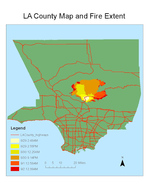
August 26, 2009, the Station Fire started in central Los Angeles County in Angeles National Forest. The fire was 98% contained by September 27, and spread over 160,000 acres (251 square miles). The fire started in the southern part of the forest and spread to the North over the next few days until it was mostly contained. Over the time period, the fire mainly stayed within the boundary of the forest. Therefore, damage to homes only could occur on the northern most border of the populated area. At least 18 homes were destroyed. The fired threatened houses and other structures in La Canada Flintridge, Glendale, Acton, La Crescenta, Pasadena, Littlerock and Altadena. The goal of this project to see what the population density looked like for areas near the fire.
My hypothesis was that the most population dense cities in the county would be minimally affected by the fire. To test this hypothesis I created a fire extent map. This map showed the extent of the fire at different times and days. My main focus was looking at the furthest extent of the fire. I created 2 buffers around the furthest extent (9/2 12:39AM). The first buffer showed the area within 2 miles of the furthest extent. The second buffer showed the area within 4 miles of the furthest extent. This illustrated which areas were under high, low, and medium threat.
I then collected data on cities and population. I found a shape file of Los Angeles County cities and added it to the map. I also found data on population of most of the cities. I joined these two attribute tables so that I could compare the different cities on the map. I decided to map population density as opposed to just population. This is because population density gives values that have already taken into account area. If two cities have the same population, the city with a larger area will have a smaller population density. This larger city will be more safe in terms of evacuating during an emergency. Though Los Angeles has the highest population, it is not very population dense because it covers such a large area. Population density, not population is what matters in terms of safety in an emergency.
After mapping out population density of different cities, I found that my hypothesis was somewhat valid. The areas with very high population densities (10,000+ people per square mile) were relatively far from the fire (8-10 miles). However, not all areas near the fire were of low population density. Some areas were still of medium population density (7000 people per square mile). However, for the most part the northern part of the populated area was not as population dense as the rest of the county. In terms of evacuation and safety, this was a very good thing. No area within the 4 mile buffer was above a population density of 8000 people per square mile.
I also looked at the elevation models of the fire extent. The graphs dealing with elevation only contain areas near the fire, not all of the county. First, I created a hill shade and 3D model of the area's elevation. I found that most of the National Forest (where the fire extended), was of higher elevation, and the populated areas were of lower elevation. I also mapped out the fire extent over time on top of the elevation models. At each time period, there is a map of the elevation and fire extent. As shown by the maps, the fire starts at the southern end of the National Forest. The fire then spreads northward. In terms of elevation, the fire generally spreads to higher elevation. It does not spread downhill into the populated areas and cities. While one could assert that the fire spread northward because it was attracted to higher elevation, that is not the most probable conclusion. It is more likely that the fire spread in that direction because of wind direction and the direction that the dry forest was located.
In conclusion, the Station Fire spread to a large area of the Angeles National Forest. Though some areas in threat of the fire were of medium population density, highly population dense areas were generally safe from the fire. This probably made it relatively easy to get people evacuated and safe as the fire spread closer to homes. Also, by looking at the digital elevation models, we see that the areas of highest elevation were in the National Forest. The fire generally stayed within this boundary of high elevation. The fire spread to the north into the National Forest.
"Station Fire Information." Lasdblog.org, 3 September 2009. Web. 30 November 2011. http://www.lasdblog.org/Pressrelease/PR_Folder/SFUpdateTH-00.pdf
"'Angry Fire' Roars Across 100,000 California Acres." Cnn.com, 31 August 2009. Web. 30 November 2011. http://articles.cnn.com/2009-08-31/us/california.wildfires_1_mike-dietrich-firefighters-safety-incident-commander?_s=PM:US
"Station Fire." InciWeb, 10 November 2009. Web. 30 November 2011. http://www.inciweb.org/incident/1856/
Garrison, Jessica. "Station Fire Claims 18 Homes and Two Firefighters." Los Angeles Times, 31 August 2009. Web. 30 November 2011. http://articles.latimes.com/2009/aug/31/local/me-fire31
"Wildfires in Southern California." The Boston Globe, 2 September 2009. Web. 30 November 2011. http://www.boston.com/bigpicture/2009/09/wildfires_in_southern_californ.html


No comments:
Post a Comment